The UC – led by IES (merged into Webgenesys S.p.A. on October 1st, 2023) aims to equipping Civil Protection’s DSS with the function of creating-and-distributing contextualized, high-resolution fire risk bulletins.
Unlike the classic definitions of hazard and risk, the currently accepted definition of Fire Risk – else ‘fire susceptibility’ – is the propensity of fires to spread IF ignited. In terms of EO and EO-borne information, the Fire Risk has the meteorological and the landscape components, each provided with its own timescale of significance: meteorological (very-high to high temporal, low-to- moderate spatial) vs. landscape (decadal, seasonal to multiannual), leveraging on geostationary (MSG) and LEO orbiting payloads (Metop, Sentinel-2 and -3, Landsat).
The UC7 target is to improve the short-term fire susceptibility forecast dynamically accounting for land use (yearly), vegetal fuels (seasonally), weather and hygro-thermal parameters on ground (hourly/daily/10-day basis).
Motivation & Value Proposition
First responders are increasingly exploiting geographic Decision Support Systems (DSS) thanks to thematic context information issued by major providers of geographic data acting at the supranational (Copernicus11, ESA12, e.g.)
and/or national (Space and/or Cartography Agencies) scale. Depending on the type of data required, such information has fast become satisfactory in space resolution (down to scales of 1:10’000 or better for vegetation or landcover- products, e.g.) thanks to the systematic production of EO-borne, multi-platform synoptical data of all type and categories. However, this is not yet the case for high-to-very high temporal resolution products targeting fast-impacting and fast- unwinding events of moderate areal extent, limited duration, little to nil-advance notice and eventually severe impact.
The stakeholders involved in EO4EU have raised evidence for other sensitive issues, frequent at the level of regional and local First Responders’ Control Rooms but not restricted to them, such as: (i) fast decisions taken during fast- developing events are mostly qualitative because of the lack of quantitative, timely refreshed information; (ii) lack in reliability and timeliness of analysis and decisions may depend on external factors as manpower availability, old fashioned procedures, incomplete, unprecise and/or missing information; (iii) with the exception of a handful of overstaffed Civil Protection centres, Control Room operators’ and First Responders’ duties do not include advanced data processing; and (iv) late, syn-event synoptical information is better suited to forensic post-event investigations, that might not fall within the First Responders’ duties.
Fires, flash floods, landslides, industrial incidents, and moderate-magnitude earthquakes — among others — represent the majority of First Responders’ activities, and generally fall under the responsibility of their regional or provincial branches. These branches coordinate the intervention teams that are dispatched to the field in response to elevated risk alerts (short-term preparedness) or to ongoing events (emergency response). The requested information is ‘tactical’ in time and space, which calls for high-temporal (hours) and high-spatial resolution (meters to decametres). Since EO data and EO-borne products to date do not fit both requirements at the same time, the information conveyed to Control Rooms should spring from the appropriate, quantitative, RT/NRT blend of data from polar orbiting and geostationary platforms, and the most recent and resolved, stationary geographic data hosted in the Control Room’s DSS.
Since the main stakeholder involved in this UC is the Civil Protection of the Sicily autonomous region, and since in the last five years, Sicily has systematically recorded almost half of the burned areas annually in the whole of Italy, upon stakeholder’s request the UC7 focus was put on the tactical management of wildfires: a subject that, within the limits and as mentioned above, has the potential for wide expansion. The target audience is likely to be First Responder Organizations equipped with one or more operational control rooms and their own geographic decision support systems (DSS). However, the scope of application can be extended to farmers and their associations, forest managers and land owners, as well as urban planners and infrastructure administrators who depend on timely, location-specific environmental data.
Scalability & Exploitation potential
The ‘Improving Civil Protection Activities Using EO-Acquired Datasets’ use case focuses on the risk of forest fires and has been designed to be scalable and commercially exploitable. It serves as a strong example of how the EO4EU platform can efficiently handle EO data preprocessing and delegate domain- specific algorithms to a remote server, ensuring flexibility and performance.
The service is available via EO4EU's Rest API - OpenEO - or can be accessed within the platform, allowing users to run customised workflows and visualise fire risk forecast maps in interactive presentation tools.
The solution has been implemented and successfully tested in three regions — two in Greece and one in Italy — and is scalable for application across all European regions.
Current status
This use case delivers daily wildfire risk assessments for 24, 48, and 72-hour forecasts, mapping vegetation fire susceptibility with increased spatial resolution from the provincial level (9 provinces in Sicily) down to the municipal level, covering all 391 municipalities of the region. The solution has undergone rigorous testing against several benchmarks and has since been expanded to cover all regions of Europe. It has successfully been implemented for two additional regions in Greece which results have been tested against the EO- detected, fire Hot Spots reported by the NASA service FIRMS and the Copernicus EMS EFFIS.
The solution is fully available is the EO4EU platform: directly within the EO4EU platform by running a pre-configured, customized workflow, or externally by calling the dedicated openEO API.
Technical Details
- Overview
-
This use case focuses on enhancing the exploitation of EO datasets and the EO4EU platform as a service to improve prevention and response
capabilities within Civil Protection services. It supports the end-to-end management of operations, from risk nowcasting and short-term prevention planning to daily service activities and the coordination of
responses to major emergencies. Based on a proven, geographic, Civil Protection Decision Support System provided by IES Solutions - now Webgenesys - this UC#7 aims at showcasing EO-driven improvements in the real-time management of natural and Man-made risks. - Challenge
-
When Control Rooms deal with an earthquake, targeted and timely available information – both still and forecasted – requires being automatically updated and displayed to help in the response phase. To
date, this is mostly done by manually adding the appropriate layer when the information becomes available: which is generally late for dealing with other dynamic events, such as Forest Fires, Landslides or flash floods, just to quote the natural events. To date, many kinds of EO data, at various levels of spatial and temporal resolution, are available and beneficial for managing material and human resources that are deployed in emergencies, provided that they are geographic, precise in space and time, timely delivered and complete. The civil protection services provided by the EO4EU platform must be easily accessible from all virtual control rooms.
- Solution
-
This use case aims at improving efficiency, precision and timeliness of Civil Protection activities by addressing the need of timely targeted reaction to dynamic events, such as Forest Fires, Earthquakes, Landslides or flash floods, common in the Mediterranean region.
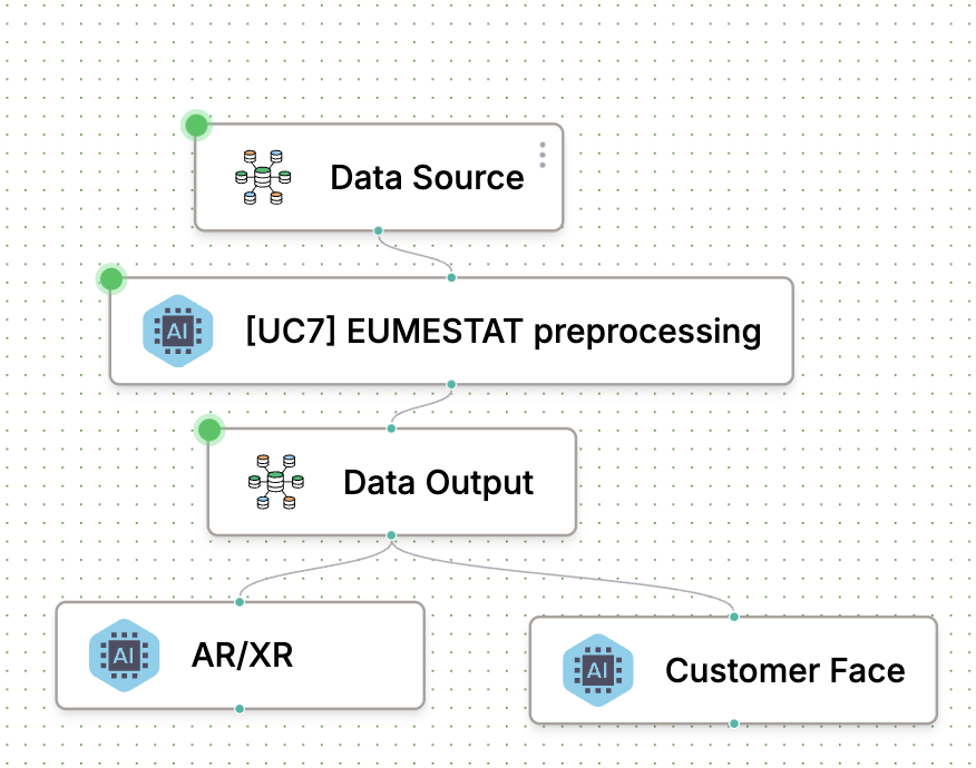
The EO4EU platform manages the entire processing pipeline:
- Fetching EO dataset, Fire Weather Index and vegetation conditions and
temperature.
- Integrating in-situ data characterizing bioclimatic, fuel, infrastructure,
morphology context area.
- Scaling and reprojecting data.
- Calling the forecasting routine, and
- Delivering results through integrated visualization tools.The only component delegated externally is the forecast algorithm, which runs on a separate server known as Jixel.
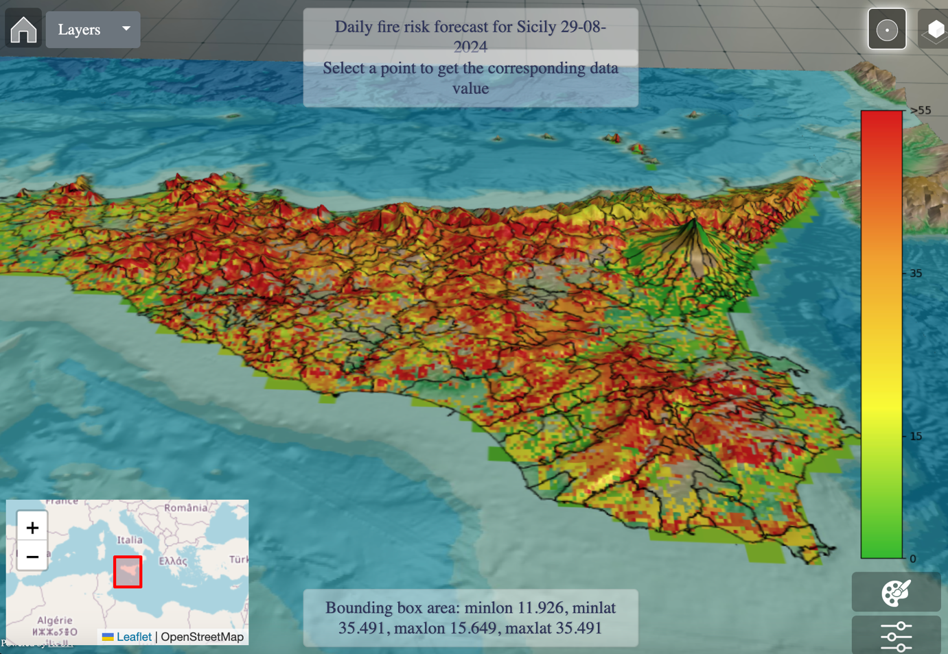
The process fully aligns with the EO4EU platform's approach, leveraging the Knowledge Graph module to retrieve EO data, using the Workflow engine to project and scale the data, orchestrating the forecast algorithm, and visualizing the results accordingly.Fig 2 - Fire risk forecast map at pixel scale
The daily wildfire risk forecast service can also be accessed via the EO4EU platform through the openEO API and delivered to a Civil Protection Decision Support System (DSS) upon authentication. The service requires the client ID (identifying the DSS), the forecast date (e.g., tomorrow), and the requested forecast timeframes (24, 48, or 72 hours). The resulting forecast maps are made available for download from a dedicated storage bucket within the platform, using the same RESTful APIs.
Input data
- FRM Fire Risk Map (LSA_SAF - EUMETSAT)
- NDVI ENDIVI10_metop (LSA_SAF - EUMETSAT)
- Corine Land cover 2018 (Sentinel-1, Sentinel-2)
- Static maps (bioclimatic, Fuel, infrastructure, morphology)
The FRM provides the FWI at 24, 48 and 72 hours, estimating the most probable degree of fire danger.
The global product ENDVI10_metop obtained from the synthesis of the best available diurnal observations recorded during each decade (1-10; 11-20 ; 21-30 ou 21-31) by the Earth observation system MetOp-AVHRR, syntheses the Normalized Difference Vegetation Index enriched with the land surface temperature (LST). Static datasets, uploaded once, are related to the morphology of the territory, the road network, the urban and the climatic/meteorological type defining the context area.
Impact achieved thanks to the EO4EU Platform
This use case integrates EO4EU's intelligent automation—offering timely and robust multiparametric processing capabilities—into a sector where information analysis is often subjective and may frequently lack reliability and timeliness due to factors such as manpower availability, outdated procedures, and incomplete, imprecise, or missing geographical information, among others. The platform ensures continuous EO data connectivity and availability, at various levels of spatial and temporal resolution. All operations related to EO dataset consumption are executed on the platform. It is possible thanks to the ability to identify the best EO imagery for a specific area on the basis of the application in other areas EO4EU enhances real-time management activities in control rooms by providing high-refresh EO services.
The main preprocessing operations are performed within the platform, while specialized model computations are delegated to external servers. Furthermore, the results can be utilized for VR visualization.
Originally developed for the region of Sicily in Italy, the fire risk forecast service is now available for any region within the European boundaries.
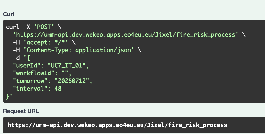
Fig 3 – API fire_risk_process example to run the service


This use case brings-in EO4EU intelligent automation - therefore, timeliness and robust multiparametric processing capacity - to a sector where information analysis is mostly subjective and may frequently lack in reliability and timeliness depending on external factors as manpower availability, old fashioned procedures and incomplete/unprecise/missing geographical information, among others.