DANAOS, a global leader in container ship management, seeks to enhance the operational efficiency, safety, and sustainability of long-haul voyages using EO4EU’s Earth Observation (EO) data fusion and high-performance optimization capabilities. This use case focuses on leveraging EO4EU to deliver real-time, data-driven weather routing optimization for large container vessels traveling transcontinental routes.
Commercial Motivation & Value Proposition
For shipowners like DANAOS, fuel consumption, schedule reliability, and safety directly impact profitability, compliance, and charter performance. EO4EU integrates high-resolution EO data (e.g., Copernicus marine data, GRIB2 forecasts) with onboard telemetry and vessel-specific profiles to deliver precision route optimization that responds to constantly changing ocean and weather conditions.
By reducing route planning time and increasing forecast accuracy, EO4EU enables:
- Faster optimization cycles (20–40% process time reduction)
- Improved routing accuracy (20–30% better fit vs. current methods)
- Lower fuel usage and emissions, supporting IMO decarbonization goals
- Safer navigation through complex sea regions with variable weather
Strategic Commercial Applications
- Real-Time Voyage Optimization: Ashore optimization engines analyze EO and sensor data to continuously refine routing advice, increasing efficiency in high-volume trade routes (e.g., Asia–Europe, Atlantic crossings).
- Just-in-Time (JIT) Arrival Management: Enhanced forecast precision enables better coordination with ports, minimizing idle time and demurrage costs.
- Dynamic Seasonality Modeling: EO4EU supports route planning across varying seasonal conditions, improving vessel utilization across the year.
- Post-Voyage Performance Analytics: Comparing master decisions with EO4EU-optimized routes provides actionable insights for continuous improvement in fleet operations.
Scalability & Exploitation Potential
DANAOS envisions expanding EO4EU-enhanced routing across its entire fleet, transforming route planning from a manual, experience-based task into an AI-assisted decision-making process. The integration of EO4EU into existing TRL7 onboard systems creates a commercially viable product offering that can scale to:
- Other major shipping lines (as a subscription routing service),
- Port authorities and terminals (JIT traffic management),
- Insurance providers (route-based risk modeling),
- Carbon trading platforms (verified emissions reduction via efficient routing).
Current status
Through the EO4EU platform, the use case and Danaos have implemented an ETL pipeline that continuously harvests weather data and integrates it with operational data from vessels to optimize fuel consumption and routing. This pipeline helps train models that accurately predict fuel consumption (FOC). These predictions are utilized in real-time to suggest alternative, environmentally friendly routes, ensuring compliance with regulatory standards.
Additionally, a Convolutional Neural Network (CNN) has been developed to monitor ocean conditions and predict ambient weather phenomena in real-time. The current work benchmarks weather data with different spatio-temporal granularities, improving the reliability of route optimization models.
Technical details
- Overview
-
The integration of cutting-edge technologies into maritime operations has become increasingly essential for enhancing voyage efficiency, ensuring safety, and reducing environmental impact. In this regard, the ocean monitoring use case of EO4EU represents a crucial advancement in the realm of maritime data management and optimization.
The use case focuses on creating a seamless connection between the pre-existing Danaos Voyage Optimization module and the EO4EU Platform, employing advanced data analysis and modern technological tools. This integration aims to significantly improve the adaptability and functionality of the maritime system, thereby transforming operational practices within the industry. By enabling real-time access to high-precision weather data and predictive analytics, the initiative promises to streamline decision-making processes and optimize voyage planning.
The primary goal is to establish a seamless gateway, ensuring the smooth transfer of weather-related datasets between the platforms. By linking these platforms, this use case ensures that weather forecasts, sea state predictions, and routing recommendations are constantly updated and available for operational use.
The target audience for this initiative includes:
- maritime industry experts
- data scientists
- weather-routing specialists
- technology developers working on maritime optimization and navigation systems
Below, we illustrate the use case owner (DANAOS) namespace (existing voyage optimization module) in high level and the EO4EU Platform Integration.By addressing the needs of these professionals, the use case aims to revolutionize maritime data management, improve operational efficiencies, and offer advanced solutions for environmental sustainability through optimized routing and fuel consumption strategies.
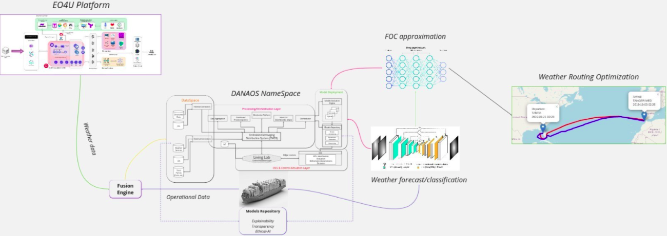
EO4EU ocean monitoring use case proprietary cluster and interconnection with EO4EU. - Challenge
-
Optimal Weather Routing is an NP-hard problem. The International Maritime Organization (IMO) recognizes that weather routing must be available to shipping in the form of recommended “optimum routes” for individual crossings of the oceans. Practice of weather routing has proved of benefit to ship operations and safety as well as to their crews and cargoes. Hence, for substantially large routes (e.g., trans-Atlantic), the computational time may even reach 20-30 mins per run. Hence, even a small increase in granularity (i.e., one point every 0.5 degrees) may lead to computational times that exceed an hour, which is unacceptable for the standards set for the service.
DANAOS Shipping is one of the largest managers of modern, large-size containerships voyaging through the open seas, planning trips that last many weeks. EO4EU aims to limit the solution space and increase the throughput reducing the computational time. Such an approach will have a positive impact on ships travelling, towards their destination, as it will limit the time of the optimised route.
Shipping deployed in long distance liner services will be engaged. The whole process is described in the following steps/phases:
- Phase 1 Before vessel departure: The navigational Officer on board plots a voyage plan. Then synchronisation of the on-board version with the main optimization engine ashore allows continuous monitoring and update of Master’s route plotting decisions along the voyage and any deviation from the initial plan. Routing advice is sent back to the vessel where the Master is able to visualise the optimised route with respect to the forecasted weather en route.
- Phase 2 Post voyage route assessment: At the end of the voyage performance results will be displayed (travel time, consumption, average speed, etc.) while a voyage performance comparison will be triggered between the actual route, driven by the master’s decision, and the system’s route advice baseline. Both routes will be fed with real weather data and will be assessed against actual voyage conditions.
- Solution
-
The EO4EU platform plays a pivotal role in ocean monitoring by enabling real-time acquisition and analysis of weather data. Through user-tailored workflow instantiation using an ETL pipeline (see the first figure below).
EO4EU ocean monitoring use case workflow instantiation for data acquisition, processing, training (annotation) and deployment The platform facilitates seamless data fusion by mapping operational vessel data with environmental parameters derived from Sentinel-3 imagery and NETCDF datasets (see images below).
This process primarily focuses on inferring critical sea state conditions, such as wind speed and direction, essential for maritime operations. A knowledge graph module, integrated within the EO4EU GUI, allows for the continuous retrieval of satellite imagery, which is then annotated and structured to train a Convolutional Neural Network (CNN) for enhanced weather forecasting.
Upon further fine-tuning and validation the model is wrapped as a containerized service (SaaS) via readily available automation mechanisms provided by the EO4EU cluster.
The figure above depicts the two-fold process of model validation. In the first step the accuracy of the CNN is assessed and in a latter stage quantification of the performance of the FOC approximation model by integrating granular weather data is initiated.
The trained model is subsequently deployed to provide real-time meteorological insights, which are further integrated into a voyage optimization module (see figure below). This holistic approach enables dynamic route adjustments, improving fuel efficiency, safety, and operational effectiveness in maritime navigation.
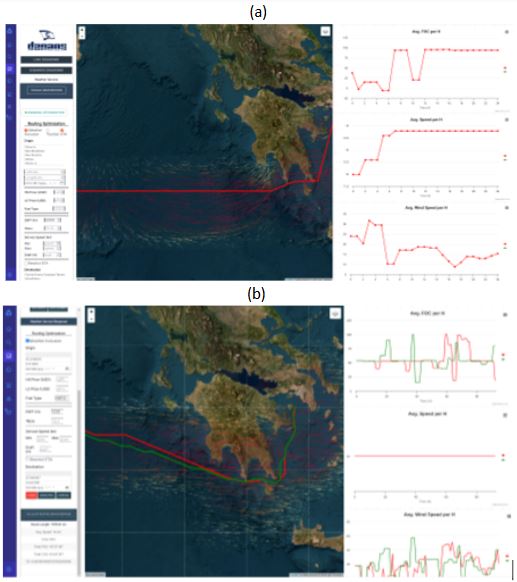
Routing module integrating weather forecast data. Red route indicates voyage conducted by the captain, green route is the optimized route by taking into account weather forecasts, and projected savings. - Jupyter Notebook
-
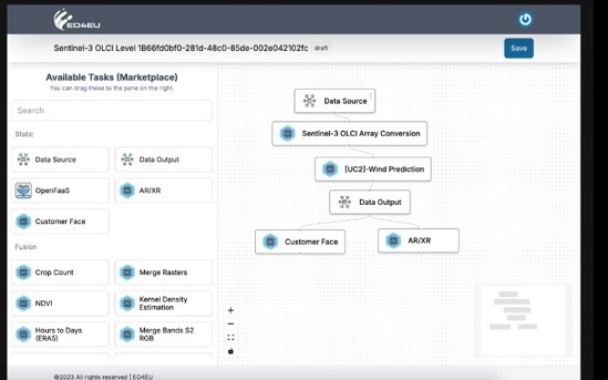
Wind Prediction for EO4EU Use Case - Ocean Monitoring (.ipynb)
This Jupyter Notebook demonstrates how to predict ocean surface wind patterns using Earth Observation data. It includes authentication and API setup for accessing EO4EU services, likely retrieving and processing remote sensing data. The workflow starts by connecting to EO4EU services, installing required libraries (e.g., cdsapi, openeo), and preparing for data-driven wind analysis. The focus is on developing predictive tools that support ocean monitoring applications, such as maritime navigation and environmental assessment.
Watch the workshop recording on the Ocean Monitoring Use Case
Input data
-
Meteorological Data: Collected from various Earth Observation (EO) sources (Sentinel Hub and more specifically, Sentinel 3), offering high granularity.
-
Vessel Operational Data: Data from on-board sensors, capturing real-time information like speed, fuel consumption, and environmental conditions.
-
Weather Routing Data: Used to improve route optimization, focusing on safety, fuel consumption, and timely arrival.
Impact achieved thanks to the EO4EU Platform
This use case not only enhances the economic performance of voyages through optimized fuel and time management, but also supports the EU Green Deal by reducing carbon emissions in commercial shipping. EO4EU positions itself as a key digital enabler for smart, sustainable, and profitable ocean transport in the era of zero-emission logistics.
As of the most recent developments, the ocean monitoring use case has made significant progress in the development and integration of key systems that enhance maritime data management and voyage optimisation, by defining the preliminary architecture and incorporating state-of-the-art frameworks and gathering the requirements to gateway between the pre-existing Voyage Optimisation module and the EO4EU Platform. This integration allows for seamless data transfer and enhances real-time decision-making, marking a pivotal milestone for the project.
The system has already incorporated high-resolution weather data (approx. ~0.1 degrees spatial resolution and 3-hour forecast windows) that enables precise weather forecasting and sea state predictions. These data points have been successfully integrated into the existing Weather Routing Optimisation (WRO) framework, demonstrating the practical application of the system in real-world scenarios.
The implementation of streamlined pipelines has enabled real-time acquisition, extraction, and processing of weather-related datasets. These achievements have facilitated seamless integration into the existing WRO (Weather Routing Optimisation) framework. Notably, the project has achieved a specific accuracy rate in sea state predictions, ensuring reliable data for maritime operations. These tangible results showcase the effective implementation of the ocean monitoring use case objectives.
Additionally, the implementation of co-simulation modules for weather forecasts, fuel consumption estimation, and pathfinding algorithms have significantly increased the system's ability to make real-time decisions. This functionality supports optimised routing, improved fuel efficiency, and reduced emissions, solidifying the effectiveness of the integrated platform. The system has also reached a key milestone in terms of ~96% accuracy in sea state predictions, showcasing the robustness and reliability of the data being provided for operational decision-making.
For similar end-users to this use case, the potential impacts include:
- Fuel Optimization: Reduced fuel consumption through more efficient routing.
- Regulatory Compliance: Ensuring that vessels comply with environmental regulations during voyages.
- Real-time Analytics: EO4EU allows real-time analysis of vast amounts of meteorological data to reveal patterns and correlations, improving decision-making.
- Enhanced Accuracy: Leveraging a fine-grained weather report and data-driven models, EO4EU improves the precision of route planning, thus minimising delays and maximising safety.
Watch the workshop recording on the Ocean Monitoring Use Case

EO4EU offers enhanced visualization capacity of the data obtained both by the open EO sources as well as the in-situ data collected by DANAOS, offering a multi-layer interaction with the user onboard, while augment user-friendliness and responsiveness.